


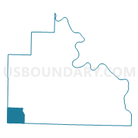
Red River Voting District, Stone County, Arkansas
About
Outline

Summary
| Unique Area Identifier | 528268 |
| Name | Red River Voting District |
| County | Stone County |
| State | Arkansas |
| Area (square miles) | 17.12 |
| Land Area (square miles) | 16.89 |
| Water Area (square miles) | 0.23 |
| % of Land Area | 98.68 |
| % of Water Area | 1.32 |
| Latitude of the Internal Point | 35.75429660 |
| Longtitude of the Internal Point | -92.37356320 |
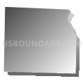
Maps


Graphs
Select a template below for downloading or customizing gragh for Red River Voting District, Stone County, Arkansas


Neighbors
Neighoring Voting District (by Name) Neighboring Voting District on the Map
- Flag Voting District, Stone County, AR
- Holly Mountain Voting District, Van Buren County, AR
- Linn Creek Voting District, Van Buren County, AR
- Union Voting District, Stone County, AR
Top 10 Neighboring County Subdivision (by Population) Neighboring County Subdivision on the Map
- Linn Creek township, Van Buren County, AR (655)
- Union township, Stone County, AR (595)
- Holly Mountain township, Van Buren County, AR (523)
- Red River township, Stone County, AR (162)
- Flag township, Stone County, AR (152)